 "DrJohannVegas" (drjohannvegas)
12/01/2016 at 14:04 ē Filed to: None
 12
12
 22
22
 "DrJohannVegas" (drjohannvegas)
12/01/2016 at 14:04 ē Filed to: None |  12 12
|  22 22 |
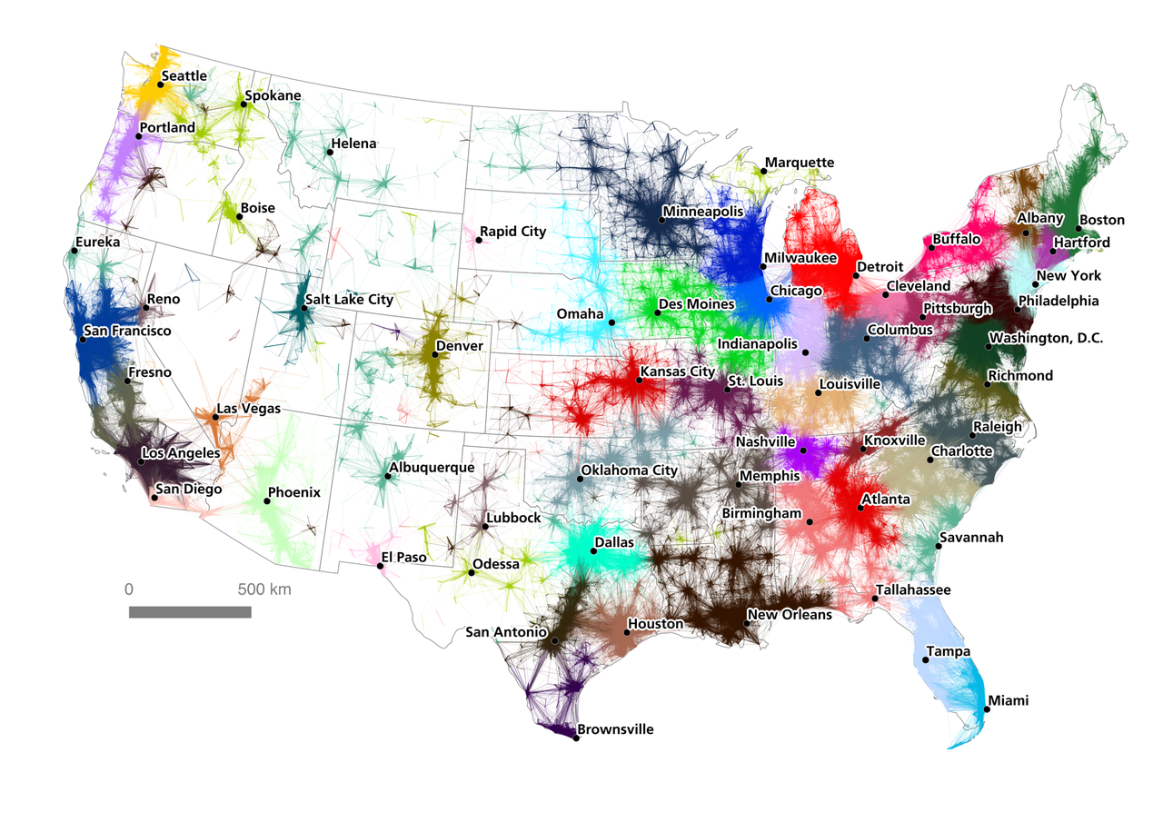
Weíve seen lots of maps of the US recently, mostly reflecting political divides. Some are accurate, others...less so. But in the same way that maps can inform, they can also blind us to features of our society.
Most maps of the US focus on political boundaries - borders defined by legal negotiations which define the limits of subnational authority. But peopleís lives donít always fit neatly within those boundaries. Maybe you cross a city, or county, or state border to get to work. Maybe you cross those borders for school, or to worship. Maybe you just like to cross borders for fun.
The map above is what happens when a computer decides how to draw borders and ignores political boundaries. Those lines (vectors) are commuter flows, one way of measuring the economic geography of the United States. Rather than think of space as what is contained by legal boundaries, we can think of the space as divided into economic enclaves. The researchers who created these maps simply asked the computer to look at a large dataset of economic connections and draw a new set of borders around economic regions.
When the computer calculates all the commuting data, it fits a new set of boundaries based on the ďconnectednessĒ of census areas. This is what you get:
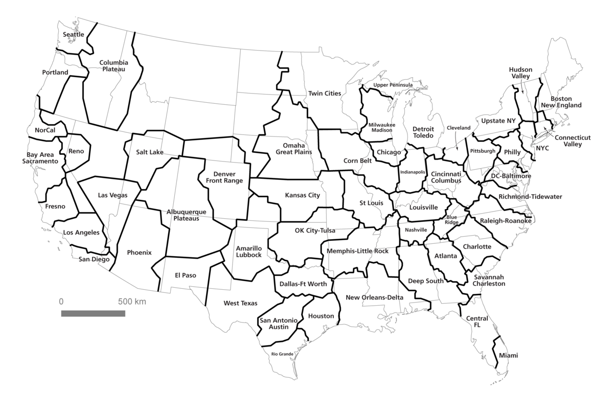
I like the top map more (because itís colorful and shows connections), but the bottom tells a really powerful economic geography story, and thatís pretty neat, too.
Hereís the Atlas Obscura article on the paper:
!!! UNKNOWN CONTENT TYPE !!!
And hereís the paper itself on PLOSOne:
!!! UNKNOWN CONTENT TYPE !!!
(Oh, and in case this wasnít a clear heads-up: Iím back, and Iíll be back to regularly posting nerdy shit on Oppo again soon.)
(Oh, Pt 2: If you want to complain that this isnít car-related, I ask you to consider how most people in the US commute to work over moderate-to-long distances.)
(Edit: Bumped for the work crowd.)
 DynamicWeight
> DrJohannVegas
11/30/2016 at 19:35 |
|
I agree with the Bay Area section of the map. Much more realistic.
 Berang
> DrJohannVegas
11/30/2016 at 19:36 |
|
Please present the info in the form of a venn diagram.
 DrJohannVegas
> Berang
11/30/2016 at 19:37 |
|

 Berang
> DrJohannVegas
11/30/2016 at 19:39 |
|
Accurate diagram of America. 100%
 Phatboyphil
> DrJohannVegas
11/30/2016 at 19:40 |
|
Kind of depressing that Montanna and other states didnít get to stay in the US :(
 DrJohannVegas
> Phatboyphil
11/30/2016 at 19:43 |
|
Apologies for going a bit techy/nerdy, but:
I suspect that the tricky thing with those areas is that any fitting threshold which would have made cohesive regions there would have caused havoc in the East and on the West Coast.
Also, they arenít ďoutsideĒ the US, they just arenít part of an economic superregion. Theyíre free and unincorporated!
 Phatboyphil
> DrJohannVegas
11/30/2016 at 20:08 |
|
That makes sense. On the plus side it could be a real wild west! But with mad max vehicles instead of horses!
 DrJohannVegas
> Phatboyphil
11/30/2016 at 20:14 |
|
It is really hard to appreciate the scale of the West (and the US in general) until you traverse it on the ground. One of my most fun grad school memories was cannonballing back from a conference in Seattle to Michigan with a colleague. We had to get back to teach on the first day of classes, so we had ~40 hours to do a ~35 hour drive. Drove in shifts, the other sleeping on and off. We were already fatigued and tired from... conference stuff. (yea, thatís it.)
Anyhow: Driving across parts of northern Wyoming in pitch darkness, with nothing but headlights and the flares of refineries to break the interminable inky abyss, one begins to see the world in a different light. The sleep deprivation didnít help. Mad Max is right.
Postscript: First dayís lecture was probably one of the best Iíve ever given.
 Honeybunchesofgoats
> DrJohannVegas
11/30/2016 at 20:25 |
|
As someone who used to commute from New Jersey to New York and now commutes from New Jersey to Pennsylvania, that really resonates with me.
I have no idea whatís going on with New Orleans though. Thatís a crazy amount of commuting.
 Stephenson Valve Gear
> DrJohannVegas
11/30/2016 at 20:57 |
|
HOKEY SMOKES BULLWINKLE! Apparently, I now live in NewOkieLand.
Now draw me a vector to depression...
 Stephenson Valve Gear
> DrJohannVegas
11/30/2016 at 21:07 |
|
I love taking road trips across the US. We donít dawdle too much; instead we tend to roll along at an exuberant rate of speed. Even so, it really give one a feel for the size and diverse geography of the United States. This spring we did a coast-to-coast run across the southern US that was a ball. I hope to do another transcontinental drive next year sometime...
 Eric @ opposite-lock.com
> Phatboyphil
11/30/2016 at 22:34 |
|
I used to work in that region. There is very little out there and nothing is contiguous enough to be an economic region there. It was so sparse that when a single Walmart opened 75 miles from where I lived, it obliterated the local economy. It was so sparse that people waved when they saw other cars on the roads (about every 5-15 minutes, on average).
It was a great place. My favorite part of the country aside from where I live now (I wish they fought for 54'40", because Iíd love to live in what is now Canada), since it would be part of that non-metro area.
 shop-teacher
> DrJohannVegas
12/01/2016 at 00:26 |
|
Interesting stuff. I couldnít help but laugh at the ďstateĒ of Chicago. People from down-state Illinois are always bitching about how they wish Chicagoland would break off into itís own state.
 Santiago of Escuderia Boricua
> DrJohannVegas
12/01/2016 at 07:21 |
|
Would also be interesting if they included cross-border commuters. For automotive, lots of people commute into Mexico or Canada every day
 davesaddiction @ opposite-lock.com
> DrJohannVegas
12/01/2016 at 09:32 |
|
I want to live in Montanevadakodahyoming
 For Sweden
> DrJohannVegas
12/01/2016 at 14:10 |
|
Columbia Plateau best mega region
 Justin Hughes
> Phatboyphil
12/01/2016 at 14:13 |
|
Probably more like Puerto Rico, except colder, and with less Spanish spoken.
 EL_ULY
> DrJohannVegas
12/01/2016 at 14:19 |
|
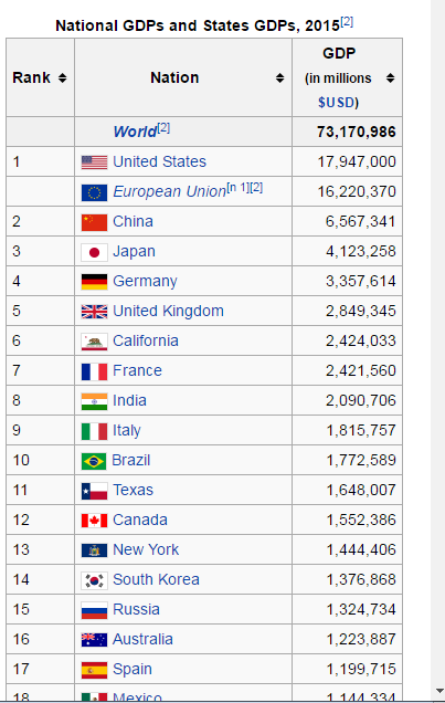
My fav: GDP
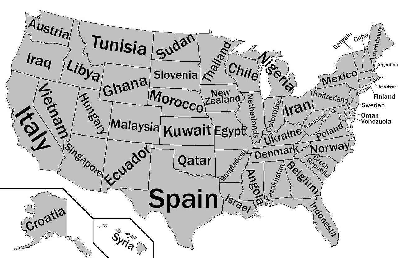
California and Texas would be in the Top ten countries list
EDIT: Juuust missed out :]
 Phatboyphil
> DrJohannVegas
12/01/2016 at 15:11 |
|
Iím about to experience that myself. Iím driving from Tacoma to Houston, starting tomarrow lol.
 DrJohannVegas
> Phatboyphil
12/01/2016 at 15:44 |
|
Safe travels, have fun!
 and 100 more
> DrJohannVegas
12/07/2016 at 16:13 |
|
Everythingís bigger in WEST Texas.
Not the other Texases, though.
 and 100 more
> For Sweden
12/07/2016 at 16:17 |
|
About the size of... Germany, perhaps, mein herr? Perhaps zees is zwei there are so many skinheads on East Oregon?
(Actually, pretty close in size!)